Pompeii in Maps. A Story of Archaeological Cartography
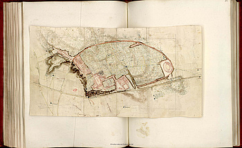
With the onset of excavations in the Vesuvius cities in the middle of the 18th century, the officials in Naples were facing the challenge to establish an adequate documentation of finds and findings. Inter alia, immediately following the first excavations plans and later on maps were created of the exposed parts of Herculaneum and Pompeii. Especially for Pompeii, where investigations have been continuously pursued ever since, an extensive panoply of various plans provides a good opportunity to track the development of an ‘archaeological’ cartography.
At first we considered publishing an illustrated catalogue of the most important plans, but during the preparations it became clear that this way we would not do justice to the importance of this complex. ›New finds‹ of lots of plans completely overlooked until then (Istituto Topografico Militare, Firenze), publications of drawings (especially by William Gell) as well as other printed plans due to the growing digitisation of library and archive holdings led to a deepened and often surprising view of the conditions under which those plans had been created.
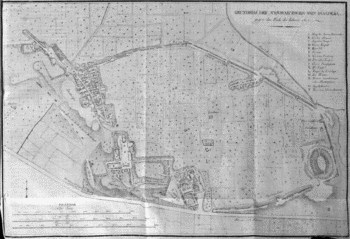
Now possible statements of a given plan could be defined better and in context with other plans they could be better understood. Everything had an influence on the plans’ designs: was the cartographer educated as an architect or as a geodesist, was it about architectural-historical or about administrative statements, were specific functions of buildings or individual quarters charted and marked, was everything published by the administration or by private publishers?
At the same time there were attempts with other three-dimensional forms of documentation, experiments with bird’s eye views and (partially reconstructing) perspectives and of course a big model of the town made of cork.
Hence Pompeii proved itself exemplary for the development of a more fundamental instrument of archaeological documentation during the early history of our discipline.
Literature
Kockel, Valentin, Archäologie und Politik. Francesco Piranesi und seine drei Pompeji-Pläne, Rivista di Studi Pompeiani 11 (2000), 33-46 (zum Volltext).
Ders., Un capitolo dimenticato della cartografia di Pompei. Gaspare Marchesi e il Reale Officio Topografico di Napoli. Rivista di Studi Pompeiani 16, 2005, 11 – 36 (full text).
Ders., Pompei 360°. I due Panorami di Carl Georg Enslen del 1826 – Pompeji 360°. Die beiden Panoramen Carl Georg Enslens aus dem Jahr 1826, Mailand 2006.
Ders., Pompeji vermessen - Plan, Modell, Panorama und andere Techniken zur Visualisierung der Ausgrabungen im 18. und frühen 19. Jahrhundert, in: Reinsberg, C. – F. Meynersen, Jenseits von Pompeji. Faszination und Rezeption, Darmstadt 2012, 54-65.
Ders., I modelli di Pompei dal settecento al "grande plastico". La documentazione tridimensionale delle antiche rovine, in: Osanna, Massimo – Caracciolo, Maria Teresa – Gallo, Luigi (Hrsg.), Pompei e l’Europa 1748-1943. Kat. Ausstellung Pompeji 2015, Milano 2015, 267-275.
Ders. – Rieger, Katharina, Appunti per una storia della cartografia di Pompei: i primi cent'anni, in: R. Morichi (Hrsg.), Nuova Cartografia Pompeiana, Roma 2017, S. 57-98.
Further Information
Project Lead
Prof Dr. Valentin Kockel
Klassische Archäologie
Universität Augsburg
86135 Augsburg
E-Mail
Together with Dr. Katharina Rieger
Funding
This project is funded by the Bavarian Academy of Sciences and Humanities.